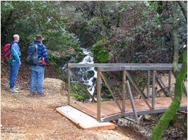
Upper Sacramento Ditch Trail - courtesy of Bureau of Land Mgmt.
The upper and lower ditch trails once brought water to 19th-century gold miners. There are lots of relics of the era to see if you know how and where to look! While the
Upper Trail is a hefty 9 miles, the
Lower section is only 2.8. Both are rated easy to moderate.
The Upper trail, starting near the Shasta Dam visitor parking lot, stretches to the trailhead at the end of Walker Mine Road. Stop on any of the three bridges to enjoy the spring-time cascades and falls on the northern portion of the trail. Take in the views of Shasta Dam, the Sacramento River, and Keswick Reservoir.
The Lower trail follows the alignment of the Sacramento Ditch south of Walker Mine Road and connects to the 4-mile
Hornbeck Trail, which follows the route of a long-abandoned, narrow-gauge railroad.